

From the NPS web site:
The Historic Bridge
In the 1870s, pioneers from Utah began to expand their settlements into northern Arizona. Nearly 600 miles (965 km) of deep canyons along the Colorado River stood in their way. One of the only places a wagon could reach the river from both north and south was at the mouth of Glen Canyon. Since the area was accessible and was a natural corridor between Utah and Arizona, a ferry was established there in 1873. Named after the first ferry operator, John D. Lee, Lees Ferry became an important route for pioneers, settlers and local traffic. In the 1920s, automobiles began using the ferry as a means to cross the Colorado River. It was recognized that it was time to find a safer, more reliable way for vehicles to cross. A bridge site was selected 5 miles (8km) downriver at Marble Canyon. Construction of the bridge began in June of 1927. This was rugged and remote country and it was difficult to get men, materials and equipment from one rim to the other, a distance of only 800 feet (244m). The ferry was used to transport materials when possible. However, on June 7, 1928, the ferry sank in an accident which killed three men. Since the bridge known then as Grand Canyon Bridge was nearing completion, the ferry was not replaced.
So, for the next several months, no direct route existed between Utah
and Arizona. People had to travel 800 miles (1287km) around the canyon
to reach the other side of the river. It was an historic day when, on
January 12, 1929, the bridge was opened to traffic. At the time, it was
the highest steel arch bridge in the world and made traveling between
Utah and Arizona much easier. No longer did travelers have to contend
with the moods of the Colorado River at Lees Ferry. The dedication of
the bridge took place June 14-15, 1929. For such an isolated spot, it
was an astounding event. Nearly 7,000 people in 1,217 automobiles
arrived for the celebration. Speeches were given by the governors of
Arizona, New Mexico, and Utah and by the President of the Mormon Church.
Bands, choral groups, and Native American dancers were also a part of
the festivities. It was reported that airplanes flew under the bridge
and as Prohibition was in effect, the bridge was christened with a
bottle of ginger ale. The bridge was known as the Grand Canyon Bridge
for five years following the dedication. In 1934, after great debate in
the Arizona legislature, the official name was changed to Navajo Bridge.
Cathy and I stayed on the bridge quite some time to watch the several boats passing underneath. Some of these inflatable boats had 35 people on them. They paid a lot of money to travel down the Colorado and through the Grand Canyon. A trip I would like to take one day.
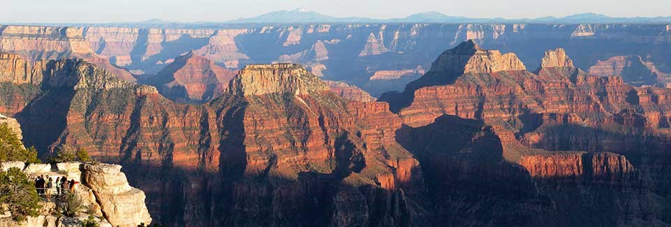
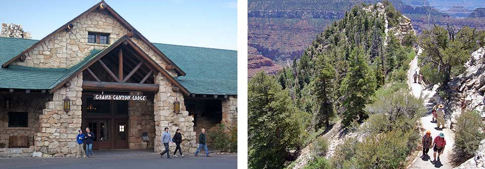
The views from the North Rim were very very nice and the change of climate from the south rim to the north rim is startling. The North Rim gets a lot of snow in the winter which forces the park to close, as it is 8,000 feet in elevation. According to the NPS web site the North Rim only gets about 10 percent of the tourists the South Rim does. So if you like to get off the beaten path, which I have recommended several times, the North Rim is a good place to visit and maybe stay. They have one lodge and one campground.
If you ever feel really adventuresome, hiking across the Grand Canyon from South Rim to North Rim is a total of 21 miles. Hiking the 21 miles from the South Rim to the North Rim includes a 4,860 foot elevation loss from the South Rim to the Colorado River, followed by a 5,850 foot elevation gain from the river to the North Rim. The oddity is that driving from the South Rim to the North Rim requires 4.5 hours and 220 miles of driving.


No comments:
Post a Comment